![](/images/other/stat-length.png)
![Trail Walking La Chaudière - les 3becs et arches - Photo](https://media.geolcdn.com/t/1900/400/97464636-1260-4d97-b592-83a9cda2a983.jpg&format=pjpeg&maxdim=2)
les 3becs et arches
nadd73
User GUIDE
![Length](/images/other/stat-length.png)
![Max alt](https://static1.geolcdn.com/siteimages/upload/files/1508320355ic_sort_altitude_max_24dp.png)
![Uphill gradient](https://static1.geolcdn.com/siteimages/upload/files/1508320355ic_sort_den_pos_24dp.png)
![Km-Effort](/images/other/stat-length.png)
![Min alt](https://static1.geolcdn.com/siteimages/upload/files/1508320355ic_sort_altitude_min_24dp.png)
![Downhill gradient](https://static1.geolcdn.com/siteimages/upload/files/1508320355ic_sort_den_neg_24dp.png)
![Boucle](https://static1.geolcdn.com/siteimages/upload/files/16400158638029165_repeat_loop_refresh_sync_direction_icon.png)
![Walking](https://static1.geolcdn.com/sitytour/trail-icons/101.png)
5h10
Difficulty : Difficult
![Scan this QR Code to open this trail in the SityTrail application](https://capi.geolives.com/qq0zvz2zws4bq2lad0pu/sitytour/trails/2946334/qr.png?size=200)
FREE GPS app for hiking
About
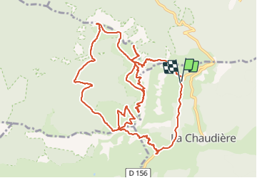
Trail Walking of 15.3 km to be discovered at Auvergne-Rhône-Alpes, Drôme, La Chaudière. This trail is proposed by nadd73.
Description
Départ altitude 912 sous le col de la chaudière.
Après 100m de piste prendre à gauche et suivre les points rouges ou bleus. Le sentier est raide à éviter en cas de pluie. Avant de monter dans le couloir prendre à gauche sur un replat pour voir 2arches.
Le couloir de monte bien, il faut mettre les mains, un passage était un peu plus délicat. Les grimpeurs le descendent.
On arrive entre la Pelle et le Signal.
j'ai fait des aller retour car arrivée à Veyou j'avais le temps donc je suis allée au rocher de la laveuse, à faire car il y a une belle Arche.
Et arrivée au pas de siara. Je suis montée pour voir l'éléphant.
Pour personnes expérimentées.
Positioning
Comments
Trails nearby
![Trail Walking La Chaudière - Les 3 Becs - Photo](https://media.geolcdn.com/t/375/260/ext.jpg?maxdim=2&url=https%3A%2F%2Fservices.sitytrail.com%2FGeolivesWS%2FDownloadMedia.ashx%3FTrailID%3D218224%26Media%3Dfix__20130901120821.jpg)
![Walking Walking](https://static1.geolcdn.com/sitytour/trail-icons/101.png)
Walking
![](/images/other/stat-length.png)
![](https://static1.geolcdn.com/siteimages/upload/files/16400158638029165_repeat_loop_refresh_sync_direction_icon.png)
![Trail Walking La Chaudière - La chaudiere - chapelle des Sadoux - Photo](https://media.geolcdn.com/t/375/260/fe29fe3e-8696-4fc7-af92-f6d3eeb26877.jpg&format=jpg&maxdim=2)
![Walking Walking](https://static1.geolcdn.com/sitytour/trail-icons/101.png)
Walking
![](/images/other/stat-length.png)
![](https://static1.geolcdn.com/siteimages/upload/files/16400158638029165_repeat_loop_refresh_sync_direction_icon.png)
![Trail Walking La Chaudière - les trois becs - Photo](https://media.geolcdn.com/t/375/260/ext.jpg?maxdim=2&url=https%3A%2F%2Fservices.sitytrail.com%2FGeolivesWS%2FDownloadMedia.ashx%3FTrailID%3D997850%26Media%3Dfix__20180701153419.jpg)
![Walking Walking](https://static1.geolcdn.com/sitytour/trail-icons/101.png)
Walking
![](/images/other/stat-length.png)
![](https://static1.geolcdn.com/siteimages/upload/files/16400158638029165_repeat_loop_refresh_sync_direction_icon.png)
![Trail Walking La Chaudière - La chaudière- chapelle des Sadoux - Photo](https://media.geolcdn.com/t/375/260/6819e1ce-f278-49e2-9b64-8d59d930cfa9.jpg&format=jpg&maxdim=2)
![Walking Walking](https://static1.geolcdn.com/sitytour/trail-icons/101.png)
Walking
![](/images/other/stat-length.png)
![](https://static1.geolcdn.com/siteimages/upload/files/16400158638029165_repeat_loop_refresh_sync_direction_icon.png)
![Trail Walking Chastel-Arnaud - montagne de Farraud - Photo](https://media.geolcdn.com/t/375/260/f18555a4-364f-4c22-b353-208a3bb34108.jpg&format=jpg&maxdim=2)
![Walking Walking](https://static1.geolcdn.com/sitytour/trail-icons/101.png)
Walking
![](/images/other/stat-length.png)
![](https://static1.geolcdn.com/siteimages/upload/files/16400158638029165_repeat_loop_refresh_sync_direction_icon.png)
![Trail Walking Saint-Sauveur-en-Diois - saint sauveur en diois - Photo](https://media.geolcdn.com/t/375/260/571ebd87-a7e9-4b87-af12-17cecb59278a.jpg&format=jpg&maxdim=2)
![Walking Walking](https://static1.geolcdn.com/sitytour/trail-icons/101.png)
Walking
![](/images/other/stat-length.png)
![](https://static1.geolcdn.com/siteimages/upload/files/16400158638029165_repeat_loop_refresh_sync_direction_icon.png)
![Trail Walking Espenel - 26 espenel zel - Photo](https://media.geolcdn.com/t/375/260/e00bd6bd-fa49-464a-aaaf-8f096ccedbaa.jpg&format=jpg&maxdim=2)
![Walking Walking](https://static1.geolcdn.com/sitytour/trail-icons/101.png)
Walking
![](/images/other/stat-length.png)
![](https://static1.geolcdn.com/siteimages/upload/files/16400158638029165_repeat_loop_refresh_sync_direction_icon.png)
![Trail Walking Bézaudun-sur-Bîne - Bèzaudun-sur-Bîne 14km. - Photo](https://media.geolcdn.com/t/375/260/6d673a6d-6a71-4890-ac2e-836b3ed377ad.jpg&format=jpg&maxdim=2)
![Walking Walking](https://static1.geolcdn.com/sitytour/trail-icons/101.png)
Walking
![](/images/other/stat-length.png)
![](https://static1.geolcdn.com/siteimages/upload/files/16400158638029165_repeat_loop_refresh_sync_direction_icon.png)
![Trail Walking Rochefourchat - Serre Délégué depuis Rochefourchat 15 10 23 - Photo](https://media.geolcdn.com/t/375/260/dd32defb-f16e-4dda-98b5-10da95afa891.jpg&format=jpg&maxdim=2)
![Walking Walking](https://static1.geolcdn.com/sitytour/trail-icons/101.png)
Walking
![](/images/other/stat-length.png)
![](https://static1.geolcdn.com/siteimages/upload/files/16400158638029165_repeat_loop_refresh_sync_direction_icon.png)